Map Group Ltd., is aware of the progress of our client’s ability to make statistic and constructed decisions. With many years’ experience in the GIS field, Map Group can provide standard and up to date applications with both local and overseas companies in the Region of Kurdistan (Iraq).
The company’s GIS presentation experts recognize the need of the participation involvement of our clients either short-term or long-term in their proposed requests. Map Group Ltd., presents its landscape information products as the groundwork for the database infrastructure for each client.
Therefore, we can prepare customized Maps to meet the specification and requirements for each client.
Map Group Ltd., has performed many projects that exceeded timeframe and quality standard of the mapping data.
Many projects required the development of custom programming to assist in the accessing of that data, as well as the connection to “enterprise wide” data servers and legacy databases to gain access to essential non-geographic attribute data.
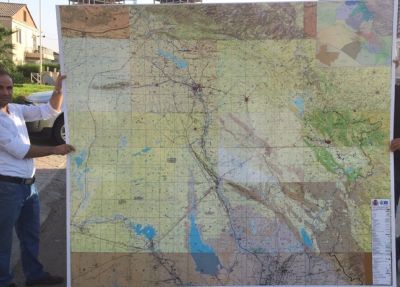
In 2013, Map Group Ltd., produced for the first time in Kurdistan history a map book that covers all Iraqi Kurdistan. The map is high quality in the 1:100k scale, containing major roads, contour lines, villages points, and village names in English and Kurdish. Also, there is a 64-page village index to easily locate on which page the preferred village can be found. The pages are in high gloss photo paper with full-color printing.
As an added value desktop software reseller, Map Group Ltd., can provide a total GIS Service that fits your requirement. By having a certified instructor on staff, we can meet your training needs through either approved ESRI programs of instruction or through customized training tailored to meet your requirements. Preparation of
In 2011, Map Group Ltd., developed a cost-effective approach for the collection, editing and translation of digital plan metric and topographic data. This approach of activation allows the program to integrate the most efficient hardware and a software system that is available to accomplish every phase of the mapping process.
PC based CADMAP/DGN software performs the real-time stereo-compilation, edge matching and entity coding. Intergraph utilizes for contour manipulation and translation and employed.
Map Group Ltd., is a national leader in changing, dissecting and updating of existing GIS databases. Utilizing the latest softcopy photogrammetric technology, Map Group Ltd., overlays the new 3D-image and drapes the existing 2D-planimetric features for a real-time changing detection mode.
Arc Info (ArcGIS and MapInfo) is utilized for preliminary graphic processing and GIS integration. PC-based software also contains function of CADD editing and graphic organization. The company implements quality control procedures at every phase of the process to ensure mapping that exceeds National Map Accuracy standards.
Verification software, operator verification, check plots, and independent editors are utilized to achieve complete and accurate of each map.
Map Group Ltd., creates framework for successful cadastral conversion projects in using 10-years of project management, digitizing and coordinate geometry (COGO) mapping experience. We create cadastral databases using a combination of precision automation techniques, including entry of distances and bearings from recorded plats, scanning and digitizing tax assessment maps. The scanned and digitized cadastral is then adjusted to “best-fit” survey control and plan metric features (centreline, edge of pavement, and buildings). A network of geodetic control points is positioned throughout the project to ensure the continuity for future database inclusion.
All sheets are created with the appropriate title block information. This allows a resolution of the hardcopy at 1000 dots per inch. The quality of the products is comparable to the continuous tone photographic quality. We also provide plotting consultation for the creation of plotting routines, hardware and software requirements and raster/vector integration, products include: